Guide Second (Navigation) Flight
Navigation Flight
NB! For this flight there is no need to have add-on maps or so installed.
Overview Nav Flight from EHSB to EHRD via VORs
You can open the above link in a different browser tab to stay oriented for the following flight 'flow':
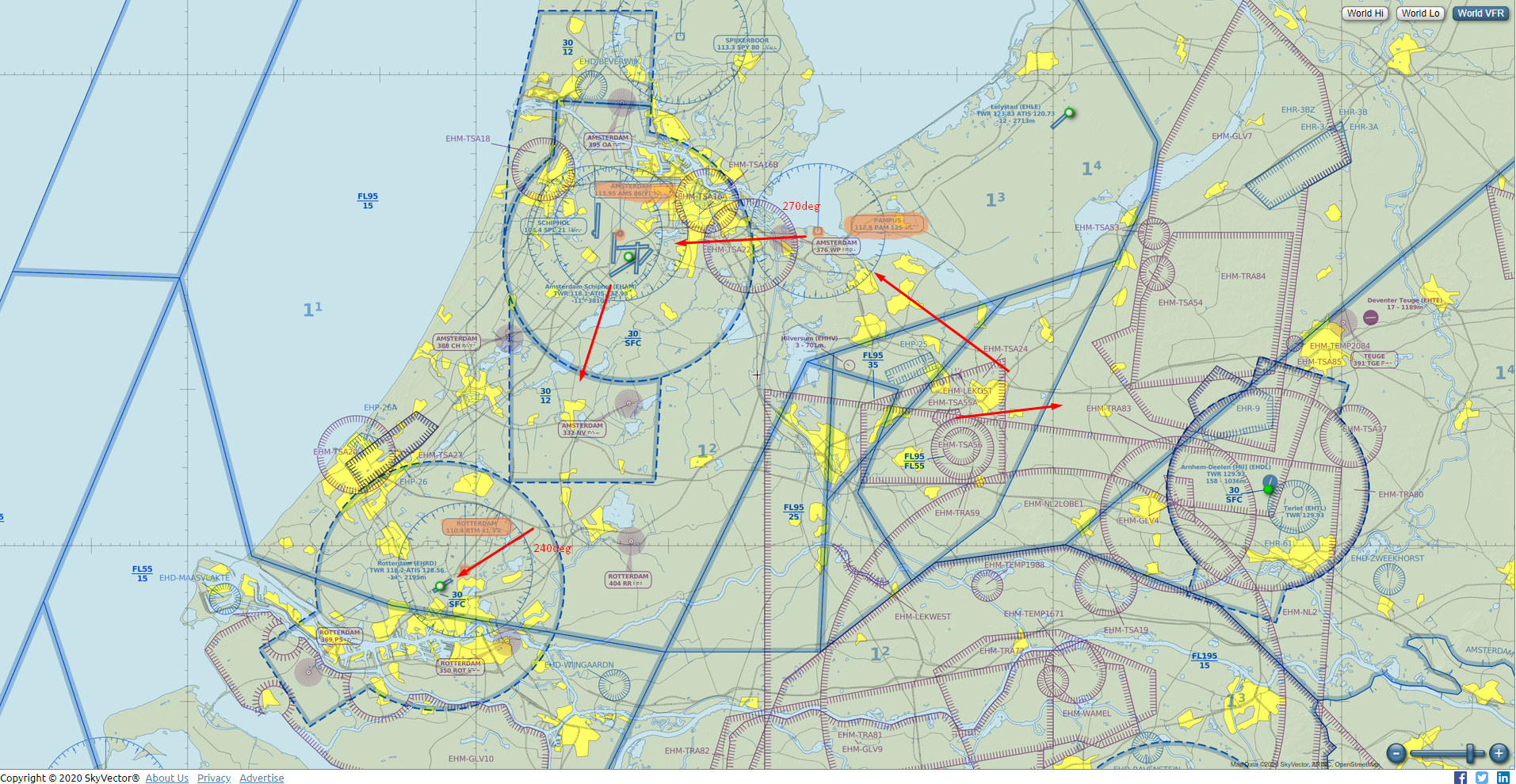
The flight fases will be similar to our 1st flight.
Briefing
The goal of this flight is to get an impression of how we could find our way in the simulated world. After T/O we'll setup for flying to Rotterdam Airport (EHRD) via several VORs. We have permission to overfly Schiphol, before turning South towards Rotterdam.
Standard Safety and Emergency Procedures apply.
WX: The weather is fine so there are no restrictions today. It is still CAVOK* and winds are light and variable.
- TYPE: We will be making a VFR (Visual Flight Rules) flight.
- AC ID / PIC: You will be PIC (Pilot in Command) in a Mooney Bravo or Mooney Bravo Retro.
- DEP: Departure airport is Soesterberg Airbase (ICAO: EHSB).
- ROUTE: It will be a cross country or Navigation flight, so the
- DEST: Destination is different this time: EHRD.
- ALTITUDE(s): Flight altitude will be between 500 and 4000 feet.
- ETD (Estimated Time of Departure): Departure time will be around noon (12:00h UTC)
- ETE (Est'd Time Enroute): The flight will be 00:40' long appx.
Preparations
If you like you can manage your flight tasks by making use of the Checklists (CL): Abbr'CL I.
It is no coincidence that the checklist is divided in different flight fases also..
Make sure you still have sufficient fuel..!
Setup your NAV radio's:
- NAV1: PAM VOR-DME (Pampus, 117.8) active; AMS VOR-DME (Amsterdam, 113.95) standby
- NAV2: you can set AMS VOR-DME (Amsterdam, 113.95) active. Optionally RTM (110.4) standby
- AP (Autopilot: leave OFF for now..): preselect Altitude to 2000ft
Flight
Remember your [P]ause button?!
- T/O from EHSB rwy 09 again, climb out on HDG 090 to minimum of 500ft..
- again we make a left turning climb: CLB to 2000ft, HDG appx. 360° or North
- turn the NAV1 OBS to centre the needle and the [TO] indication is visible. The needle now shows the HDG towards PAM VOR-DME (117.8)
- turn towards PAM directly.
- check the Distance Measuring Equipment (DME)
- want to use your [AP]? maintain your [HDG] and [ALT]; airspeed between 140 - 160 KIAS
- within 2.5 DME from PAM turn [OBS] to 270°
- when the needle moves we are coming overhead PAM: turn to [HDG] 270°; [TO] changes to [FM]
- switch NAV1 to AMS (113.95), fly inbound AMS on radial 090° {= 270° [TO]}
- when we are near to Schiphol Airport (EHAM) we get permission to overfly the arpt between 500ft and 1000ft
- Heads Up!! VFR: so you are responsible for your own separation! Do not fly into the tower or any other traffic! Once overhead we take a southerly heading (180°-190°)
- tune NAV1 to RTM (Rotterdam VOR-DME, 110.4); fly inbound RTM on course
- when within 10 NM DME from RTM start a slow descent to 1000ft. (press [B] to set the altimeter to the regional QNH)
- within 3 NM descend to no lower to 500ft.
- LDG on EHRD, rwy 24.
- vacate the rwy to the left, taxi to parking..
- Well done!
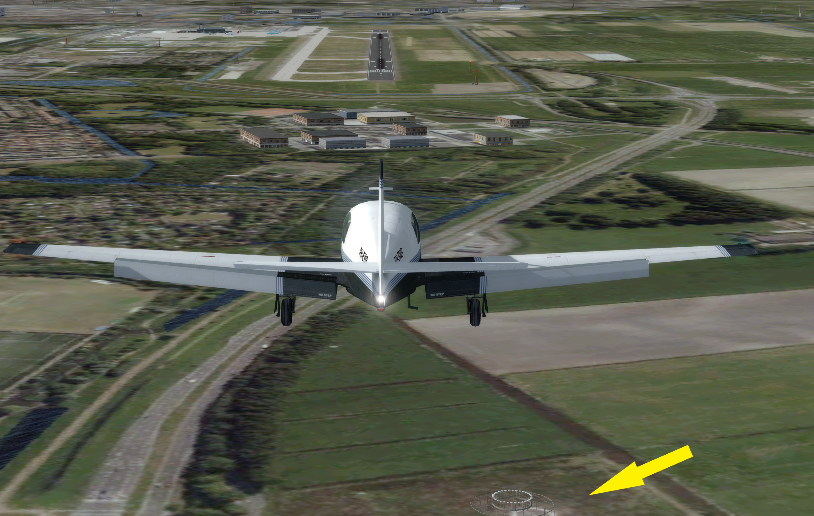 The PH-EWB, a Mooney Bravo, on final approach RWY 24 at EHRD (Rotterdam Airport).
The yellow arrow points to the Rotterdam VOR-DME facility (RTM 110.4).
| <- back | next -> | |
|---|---|---|